
Accurate borefield sizing relies heavily on having the correct ground properties. Since geothermal energy systems work by exchanging energy with the ground, obtaining precise ground data is essential for a well-designed system. In this article, we explore the key ground parameters needed for calculations in GHEtool Cloud.
Ground properties
There are many ways to classify soil geologically, including grain size, chemical composition, or mineralogical characteristics. However, for borefield design, only two key parameters are required:
- Thermal conductivity – how well the soil conducts heat
- Volumetric heat capacity – how well the soil stores heat
Thermal conductivity
Thermal conductivity measures how effectively the ground conducts heat. Borefields interact both with the ground between boreholes and the surrounding infinite ground. A borefield with higher thermal conductivity allows for more efficient heat exchange with its surroundings.
For borefields with a high imbalance, a high thermal conductivity is beneficial, as it helps dissipate excess heat into the surroundings, making the imbalance less significant. (If you haven’t yet read our article on borefield quadrants, you can check it out hier.)
Volumetric heat capacity
Volumetric heat capacity describes how well the ground can store heat. It represents the amount of energy required to increase the ground temperature by 1°C and can be thought of as the borefield’s ability to function as a heat battery.
If a borefield has a nearly equal extraction and injection demand on a yearly basis, a high volumetric heat capacity is desirable, allowing the borefield to act as a seasonal thermal energy storage (STES) system. In such cases, low thermal conductivity is also beneficial, as it minimises heat loss to the environment.
Example data
Ground properties vary significantly depending on the project location. Below is an example from the literature showing thermal conductivity and volumetric heat capacity for different soil and rock types.
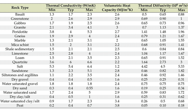
A few key observations:
- The thermal conductivity range varies widely even within the same soil type. This is due to geological differences within each category, which affect ground properties.
- For granular soils (e.g., gravel, sand, silt, and clay), thermal properties are significantly influenced by water saturation. The spaces between soil particles can be filled with either air (an insulator) or water (which has high thermal conductivity and heat capacity). As a result, water-saturated soils have much higher thermal conductivity than dry soils.
Let op
Ground property data is highly case- and location-specific. In many cases, it can be difficult to obtain precise data, especially regarding the degree of water saturation. For the most accurate information, consult local geological institutes or authorities. Additionally, in situ measurements using Thermal Response Tests (TRTs) can provide reliable ground property data.
Ground temperature
Another crucial parameter in borefield design is ground temperature. This is typically estimated by assuming a constant surface temperature and a fixed geothermal temperature gradient as depth increases.
Let op
This temperature gradient results from geothermal heat flux from the Earth’s core towards the crust. However, it is not evenly distributed across the globe with some regions have a higher or lower geothermal gradient, affecting the resulting ground temperature.

GHEtool uses this ground temperature distribution to compute the average ground temperature along the borefield, which is then used in temperature calculations.
Urban heat island effect
The assumption of a constant, linear temperature increase with depth is not always accurate, especially in densely populated areas or older cities.
As shown in the figure below, when a city is built on top of the ground, the average ground temperature rises (second graph). This is due to the urban heat island effect, where heat from buildings, roads, and pavements gets trapped, warming up the entire city. Over time, this increased temperature penetrates into the ground, forming a temperature ‘blob’ that can extend up to 100m deep.
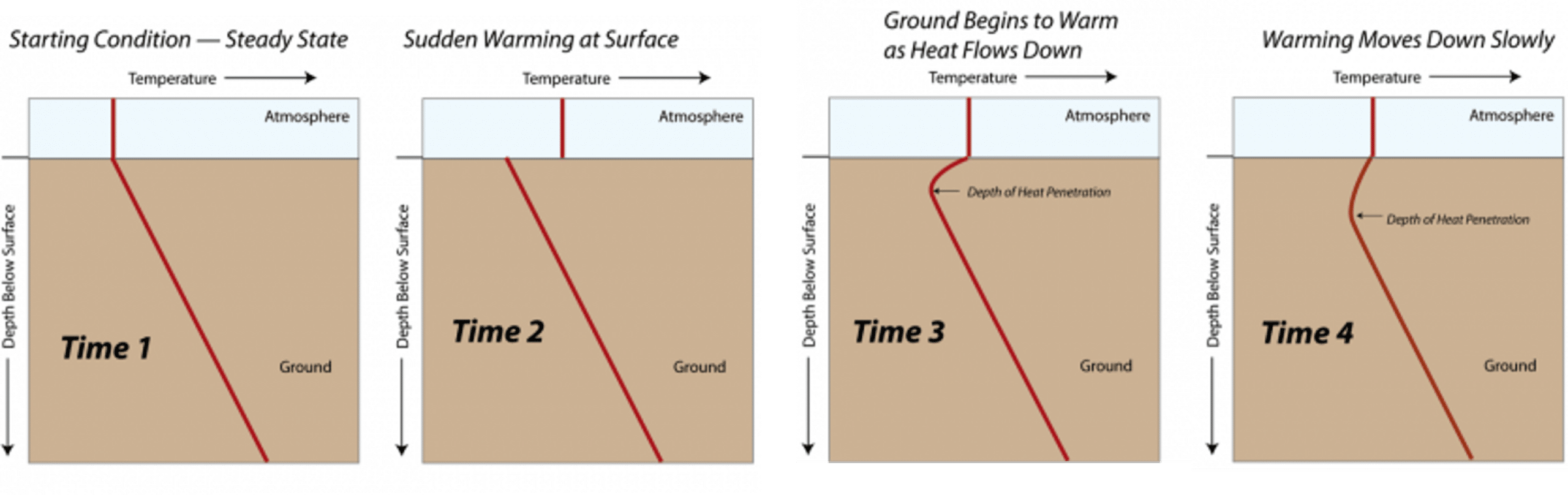
Let op
This temperature disturbance is especially important for buildings with high cooling demands. Traditionally, insights from the borefield quadrants (read the article hier) suggest that drilling deeper is not beneficial for cooling, but in some urban areas, deeper drilling may actually be necessary to reach cooler ground temperatures for efficient cooling.
Since ground temperature always carries some uncertainty, it is highly recommended—especially for large projects—to conduct a Thermal Response Test (TRT) to measure the initial, undisturbed ground temperature. (Stay tuned for an upcoming article on TRTs!)
Ground data in GHEtool
GHEtool provides two ways to enter ground properties:
- Layer-by-layer data input
- Homogeneous ground properties assumption
Since GHEtool internally assumes one averaged ground layer, both methods can yield the same result.
Layered data
The most accurate and foolproof way to enter your ground data is by using the layered option within GHEtool Cloud. Here, you can enter your ground properties layer by layer, along with the layer thickness. Using this information, GHEtool can calculate the correct thermal properties for every design based on your borehole (buried) depth.
Let op
To use layered ground data, you need the ‘Design’ licence of GHEtool Cloud. More information is available on our pricing page.
Homogeneous data
If you need to perform a quick calculation, entering all the ground layers can be quite time-consuming. Therefore, it is possible to input your ground data using the homogeneous assumption. In this case, you simply enter one value for ground thermal conductivity and volumetric heat capacity, which will be used for all borefield sizes.
Let op
The homogeneous data entered will always be an average of multiple ground layers for a given depth. If you use a borefield with a different borehole depth than the one used to calculate these average parameters, the results may be inaccurate. Therefore, if you change the borehole depth (or allow it to be calculated using the ‘calculate required borehole depth’ option), it is essential to double-check your ground properties.
Conclusie
This article discussed ground properties as a critical input parameter in geothermal design. To achieve the most accurate results, it is best practice to obtain the most precise soil data possible. For larger projects, a Thermal Response Test (TRT) is strongly recommended to measure ground properties directly on-site. Stay tuned for an upcoming article on TRTs and how to use them in borefield sizing!
References
-
- Watch our video explanation over on our YouTube page by clicking hier.
- Ground properties for Belgium: smartgeotherm or DOV virtuele boring (Flanders).
- Ground properties for France: BRGM.
- Ground properties for Germany: GeotIS.